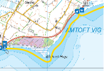
Amtoft Harbor - Here is a gravel area with free parking close to the beach / on the harbor area (GPS: 57.00596°N, 8.94255°E)
Ending point:
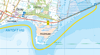
Søndergårds Mark - layby (GPS: 57.01835 ° N, 8.98516 ° E) - 4 km. Alternatively, Bygholm Vejle Information Center (GPS: 57.033158 °N, 9.101541 °E) - 13 km.
Difficulty:
Easily trained.
Special conditions:
Shallow all the way. Often only ½ - 1 meter of water.
Protection and considerations:
None before getting past Holmkær. From Holmkær and along the A11 towards Bygholm Vejle, there is a bird sanctuary. You are not allowed to row in Bygholm Vejle.
Facilities:
Accommodation:
There is a small campsite in Amtoft - Amtoft Minicamping. Amtoft Havn, 7742 Vesløs. Tlf: 97 99 32 11 (This email address is being protected from spambots. You need JavaScript enabled to view it.) (GPS: 57.006637°N, 8.941497°E)
Toilets/shower:
Amtoft Port: Toilet, shower and launderette. (GPS: 57.00596°N, 8.94255°E) Søndergårds Mark: Benches, tables and toilet (GPS: 57.01835°N, 8.98516°E)
Where to eat:
None
Shopping:
Grocery store on the harbor with reasonable range of goods: Gårdbæksvej 2, Amtoft Havn, 7742 Vesløs. (GPS: 57.00652°N, 8.94120°E)
From Amtoft Harbor, take the trip to the east - pay attention to the wind coming from the west. It can be a tough trip back. There are some very shallow areas to avoid. The tour offers beautiful slopes, beach beds and lots of birds. In Amtoft Vig at Søndergaard Mark is a place with toilet and benches/tables where you can enjoy your lunch or coffee. Nice safe trip for not so practiced. You can continue on the coast to Holmkær and on to the Naturcenter. However, it should be noted that sometimes it is so shallow that it is not possible to row along the A11. In addition, consideration should also be given to the birds in the area.
Attractions:
If you continue to the Bygholm Vejle Information Center, there is a nice view tower and some information about the birds in the area. (GPS: 57.03296°N, 9.10016°E) Bygholm Vejle: Part of 6000 ha large area owned by Aage V. Jensens Fond. There is a rich birdlife in the area. In the summer, you also see cattle that graze the area.
Vi anvender cookies til at få hjemmesiden til at fungere og at udarbejde statistik, som vi bruger til at forbedre indholdet og til navigation på hjemmesiden. Cookies der anvendes til væsentlig drift af hjemmesiden er allerede blevet gemt. Du accepterer brugen af cookies ved at klikke på "Ja, jeg accepterer".
Se vores privatlivspolitik for at finde ud af mere om de cookies vi bruger og hvordan du sletter dem.