|
Hanklit (Niels Kudsk Christensen)
|
Starting point:
|
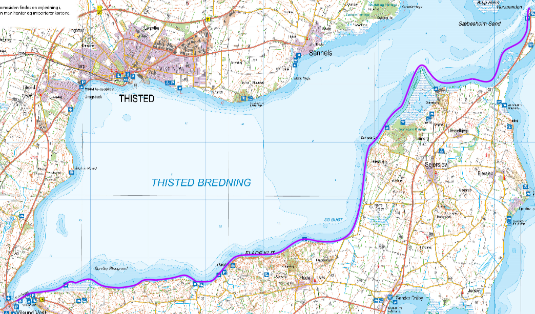
| Fæggesund Færgehavn (Mors). Right after the port, you find parkering facilities without time limits, and facilities to launch you kayak (GPS: 56.97249°N, 8.92128°E) |
Ending point:
|
| Østvildsund Lystbådehavn. Free parking and good facilities for landing either by the port or on the beach. (Sand with some stones) (GPS: 56.88445°N, 8.63802°E) |
Difficulty:
|
| Easy when wind from the east. No crossing. Difficult when winds from west over 6 m/s. |
Special conditions:
|
| If you are on round trip in Thisted Bredning: Much current when crossing by Feggesund between Thy and Mors. Best place for crossing is just north of Arup Holm. Crossing should be planned in relation to waves and currents and the ferry crossing. Alternatives: Take the ferry from Thy to Mors. Good shelter for east and southern winds when paddling along the Mors-side of Thisted Bredning. Be cautious when winds from north and west are more than 5m/s. |
Protection and considerations:
|
| Skarrehage is a seal sanctuary. No access on the beach between March 1st until November 15th. |
Facilities
|
Accommodation:
Feggesund:
- Feggesund Færgekro, Feggesundvej 81, 7900 Nykøbing. www.feggesundkro.dk(GPS: 56.973419°N, 8.921115°E)
Gullerup:
Vildsund:
- Campsite: Vildsund Camping, Parkvej 33A, 7700 Thisted – aprox. 350 m from beach. vildsund.dk-camp.dk (GPS: 56.880023°N, 8.624783°E)
- Hotel Vildsund Strand, Ved Stranden 2, 7700 Thisted – immediately at the beach. www.vildsundstrand.dk (GPS: 56.88453°N, 8.62538°E)
- Øst Vildsund Færgekro, Sundbyvej 238, 7950 Erslev – immediately at the beach on the Mors side. www.vildsundkro.dk(GPS: 56.88454°N, 8.63876°E)
- Shelters with campfire and primitive toilets. On Skyumvej towards Skyum (GPS: 56.876168°N, 8.629706°E). Water can be fetched at port. It is difficult to dock right by the shelter site, due to the stone settings.
Toilets/shower:
Salgerhøj:
- Aprox. 300 m from the road there is toilet and drinking water (GPS: 56.89356°N, 8.78564°E)
Hanklit:
- Aprox. 400 m from the road there is toilet and drinking water (GPS: 56.89032°N, 8.74921°E)
Østvildsund:
- Toilet at the port right opposit the Østvildsund Færgekro (GPS: 56.884300°N, 8.638383°E)
Where to eat:
Feggesund:
- Feggesund Færgekro, Feggesundvej 81, 7900 Nykøbing, www.feggesundkro.dk (GPS: 56.973419°N, 8.921115°E)
Gullerup:
Vildsund:
- Cafe Cavallini, Gl. Færgevej 25, 7700 Thisted, www.cavallini.dk GPS: 56.88291°N, 8.62728°E)
- Hotel Vildsund Strand, Ved Stranden 2, 7700 Thisted, www.vildsundstrand.dk (GPS: 56.88453°N, 8.62538°E)
- Øst Vildsund Færgekro, Sundbyvej 238, 7950 Erslev, www.vildsundkro.dk (GPS: 56.88454°N, 8.63876°E)
Shopping:
Vildsund:
- OK Plus, Vildsundvej 15, 7700 Thisted (limited selection) (GPS: 56,88277°N, 8.62660°E)
Landing Spots:
- Skarreborg (GPS: 56.950608°N, 8.874756°E)
- Ropsøvej ved Sejrslev (GPS: 56.937683°N, 8.840527°E)
- By Skibsted Strand, Flade (GPS: 56.90124°N, 8.78749°E)
- By Hanklit (GPS: 56.89324°N, 8.74779°E)
- By Gullerup Strand (GPS: 56.88914°N, 8.73362°E)
- By Østvildsund by the port - Pavillon where you can eat (GPS: 56.88445°N, 8.63802°E)
|
Kayak Rentals:
|
| None |
Tour Description:
|
|
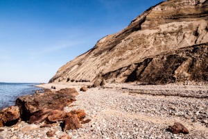
After passing over Feggesund from Thy to Mors - or inserting kayak on the Mors side, you travel south. The first possible stop is not more than 1 km away. Here it is possible to get up to Moler Museum of the road - about 1km. Shortly afterwards you row on and pass Skarrehage. A seal sanctuary, where there is often plenty of opportunities to observe seals. Some kilometers further down you meet the first of the moler clint as Mors is famous for. Here are significant chances of finding fossils. There are information boards relatively close to the beach. Shortly after Skærbæk Klint there is a meadow, where there are excellent opportunities for landing. Shortly after you see Mors’ highest point (Salgerhøj), which, on the top, provides a great view of both Mors, Thisted Bredning and Thy. Also here it is possible to go ashore and study the information boards. Some kilometers further down is Hanklit - Denmark's largest Moler clint. An amazing sight. Here, too, there is ample opportunities to find fossils. Information board just after creeks ending. Gullerup Beach comes shortly after - also here it is possible to go ashore. After that there is 8 km of coastal meadows - many birds, but also very shallow in several places before the Vildsund bridge can be seen and passed. Best place to dock in the harbor at Østvildsund. Here there is parking, toilet and a pavillion where you can sit and eat your food. Alternatively, you can eat at the Inn.
|
Attractions:
|
- Molermuseet: Aprox. 900 m from the beach at Skarrehagevej. The address is Skarrehagevej 8, 7900 Nykøbing
- Skærbæk Klint: Moler clint. Many fossils
- Salgerhøj – The highest point on Mors – 89 m
- Hanklit: Denmarks largest moler clint. 60 m high
- Vildsund bridge
|
Links:
|
|
visitmors.dk – turistbureau for Mors.
kystruten.dk – homepage about the coast around Mors.
|
|